Drainage Basin (Cambridge International IGCSE Geography)
Exam board Cambridge International · IGCSEUpdated 2024-11-27
The Drainage Basin Process
Spec point —
2.2.2
The Drainage Basin Processes
Drainage basin
- A major part of the hydrological system, drainage basins drain all the water which lands on the Earth's surface
- A drainage basin is an open system
- Every drainage basin is unique and is different in shape and size, with different rock types, relief and land use
Drainage basin features
-
All drainage basins have some features in common:
-
Watershed
- This is the boundary between drainage basins
-
Source
- The furthest point from the mouth where the river starts can be an upland lake, spring or glacier
-
Confluence
- The place where two or more streams/rivers meet
-
Tributary
- A stream or river flowing into a larger stream or river
-
Mouth
- Where the rivers enter the sea/ocean or sometimes a lake
-
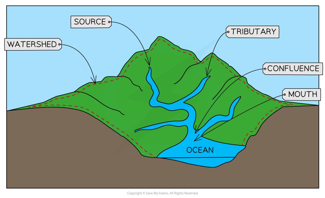
Drainage Basin Features
Channel network
-
Every drainage basin is covered by a network of tributaries that connect to the main river channel. The number of tributaries in a drainage basin is referred to as the drainage density:
- Drainage basins with lots of tributaries have a high drainage density
- Drainage basins with few tributaries have a low drainage density
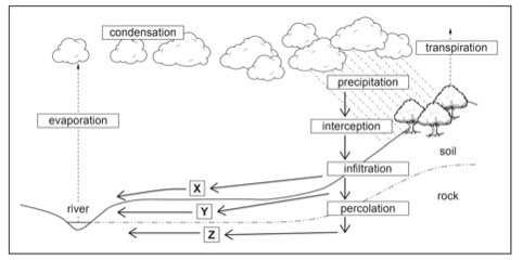
Worked Example Study Fig. 1, which shows information about flows through the drainage basin
(i) What is meant by transpiration?
[1 mark]
Final answer: Answer
- The changing of water to water vapour by plants/evaporation of water by plants/trees/vegetation [1]
(ii) Identify the processes that take place at X , Y and Z in Fig 1.
[3 marks]
Final answer: Answer
- X = Overland flow/surface runoff [1]
- Y = Through flow [1]
- Z = Ground (water) flow [1]
Was this revision note helpful?
Build on this topic