Patterns of Settlement (Cambridge International IGCSE Geography)
Patterns of Settlements
Spec point —
1.5.1· Explain the patterns of settlement
Categorising settlements
-
A settlement is a place where people live and carry out a range of activities—trade, manufacturing, agriculture, etc.
-
They can be categorised through their pattern
-
However, there are other factors that influence settlements, such as their:
- shape or form
- site and situation
- function and hierarchy
- change and growth: modern-day settlement patterns are changing due to population change, technological developments, changing lifestyles and expanding urban limits (rise of the megacities and urban sprawl)
Pattern
- Settlements come in different shapes and sizes called patterns and the physical geography of an area dictates these patterns
- These patterns range from isolated buildings in rural regions to urban megacities of over 10 million people
- Urban towns, cities, conurbations and megacities are usually densely populated over a smaller area
- Rural towns and fringe areas are usually densely populated over a larger area
- Villages and hamlets usually have a lower population density and smaller settled areas
Settlement Patterns
Form or shape?
-
When it comes to describing the pattern, both mean the same thing—it is how the settlement is laid out
-
A river, railway, or major road, for example, would support linear growth along this route to bring in trade
- A linear settlement will also form because of poor drainage or the position of a mountain
-
Circular shapes grow around a central feature, like a village green or lake, and are set up so that the middle is still easy to get to
-
When several roads meet and homes are built along those roads, they make a star- shaped settlement
-
T-form settlements happen where two roads meet
-
Y-form towns happen where two roads meet, and homes are built along these roads
-
Cruciform shapes happen at cross-roads, where homes group together (nucleate) and spread out in all four directions
-
Cross-shaped is like a cruciform, but the houses will line up along the road instead of being clustered around it
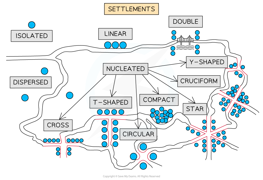
Diagram showing various settlement patterns
-
Dispersed
- Where isolated houses or farms are spread out in fields or along roads instead of all being in one place
- Found in rural areas with few people, like the Sahel region of Africa, the outback of Australia, or the mountainous parts of Scotland and Wales
- In England in the 1600s and 1700s, settlements were dispersed because big rural estates were broken up
- Extreme weather—too hot, wet, cold, or dry—also leads to dispersed villages because it makes settlement growth less likely
-
Linear
- Because of the way the land is shaped, villages tend to line up along a river or trade and transport route
-
Nucleated
-
These form when a lot of towns are close together around a central feature like a church, a village green, a crossroads, or something else
-
Further out, there are fewer buildings. These small towns are called hamlets or villages, based on their size and purpose
-
There are many reasons for the development of nucleated settlements, such as:
- defence
- trade
- co-operative community: agriculture, water, work
- floodplain: safer to group on a hilltop
-
Exam Hint Make sure you can define the terms urban and rural. You might think it is easy, but as settlements change, so does their position in the hierarchy.
- Rural: an area with less than 10,000 people living within its boundaries
- Urban: an area with more than 10,000 people living within its boundaries
This use of a figure helps to keep the definition clearer and it is easier to discuss the types of settlements found within.
- Rural: dispersed, hamlet, village and small market town
- Urban: large towns, cities, conurbations and megacities
Was this revision note helpful?