Characteristics of Urban Land Use (Cambridge International IGCSE Geography)
Land Use in Urban Areas
Spec point —
1.6.1· Describe the characteristics of land use in urban areas
Urban land use
-
Urban land use refers to activities that are found in towns and cities
-
All urban settlements have recurring features:
- A central core or central business district (CBD)
- Industrial areas—inner-city ring
- Different residential districts—suburban ring
- Outer zones of suburban expansion—urban fringe
-
All towns and cities tend to grow outward from a historic centre or core to an urban fringe
-
Each zone grows due to the needs of the city during its development over time
-
As a general rule, all towns and cities, regardless of place or level of development, show the same four features:
- A central core
- An inner-city zone
- A suburban zone
- An urban fringe
Central core
-
The oldest part of a city with features such as:
- the central business district (CBD), e.g. banks, retail and commercial offices
- multi-storey development, with vertical growth rather than horizontal due to lack of space
- land of high-value
- concentrated retail and office space
- pedestrianisation for high footfall
- convergence of public transport
- traffic restrictions for private vehicles
- low residential population
Inner-city zone
- A 'frame' to the inner core, which developed as the core developed
- Older, compact, terraced 'worker' housing to support a growing population density
- Surrounded by older industrial areas
- Areas are centred around transport links and access to manufacturing
- Available land increases with distance, so costs are reduced
- Residential land is in direct competition with commercial usage
Suburban zone
- Residential areas
- Emergence of segregated residential zones based on wealth, ethnicity, choice or government policy (e.g. social housing)
- Semi- and detached housing with gardens
- Tree-lined avenues and cul-de-sac
- Smaller retail premises
- The cost of land decreases but the size of the property increases with the distance
Urban fringe
-
These are the outer edges of the city where:
- the countryside is eroded through the urban spread/sprawl
- housing is clustered into estates, which increases 'spot' density
- some industrial land uses
- accessibility is best
Other similar characteristics
-
Other characteristics of modern urban settlements include:
- From the core to the fringe, the age and density of the buildings decrease
- Different zones have different levels of grandeur, purpose, design, and style
- Land use and population density change over time
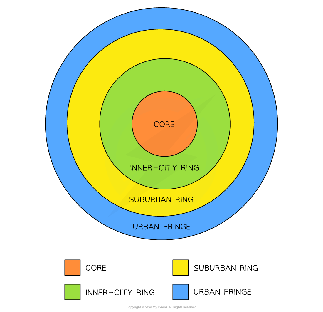
The four zones of cities based on Burgess's Concentric Ring theory
- Although the model above is simplified, it shows that the majority of business activity is concentrated in a core
- Usually with the highest land value, the CBD is also the most easily accessible due to public transport
- Because of the high demand for property, high-rise buildings are seen here; for example, Singapore, New York, and Hong Kong are well known for their 'skyscrapers', and land prices are among the highest in the world
Exam Hint
- Every model is a simple representation and applies to virtually all urban areas across the globe, but each zone varies in character, use and people depending on circumstances and where they are found.
- In LEDC cities, the urban fringe has illegal squatter settlements or shanty towns as its 'housing estates'.
- But, in MEDC cities, the poorer zones are the inner city with industry at the fringes, for easy access to motorways.
- Gentrification and redevelopment in inner cities are more common in MEDC cities
- Same features but different characteristics/uses.
Peak land value
-
Any land that has 'purpose' will be valuable and cost more to buy or rent
-
Usually, retail shops can make money and look for prime positions
-
Therefore, land uses of similar activities will come together, creating 'peaks' and 'troughs' of land values across the urban landscape
-
There are two points to consider:
-
The value of the land:
- Varies across the urban areas
- Usually decreases from the centre, outwards
- Higher land prices are also found along main roads, urban hubs and around ring roads
-
The location of the land:
- Is important to value
- The closer to key functions, the higher the value
- Accessibility and desirability increase land value
-
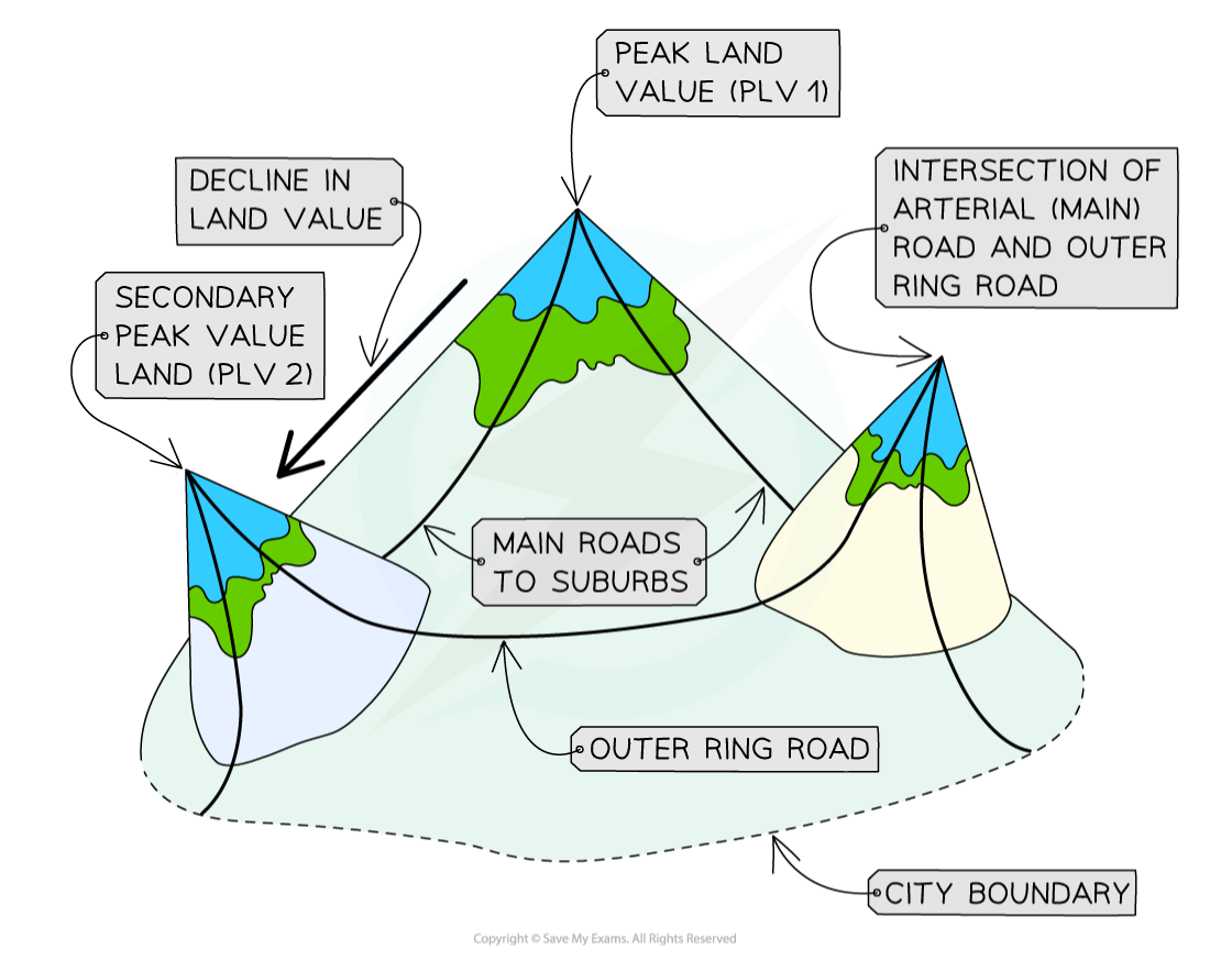
Diagram illustrating urban land value peaks
Bid-rent theory
-
Also known as 'distance decay theory', where the price and demand for land change as the distance from the CBD increases
-
Different land uses will compete for desirable plots to maximise their profits
-
Accessibility increases the potential for more customers
-
There is a trade-off between accessibility and the cost of the land
- The closer to the CBD the more desirable land is to retail and the higher the price charged/paid
-
Industry cannot compete with high prices so moves further away from CBD
-
Residential land is outpriced across the zones, but competition is less so value decreases as more space becomes available
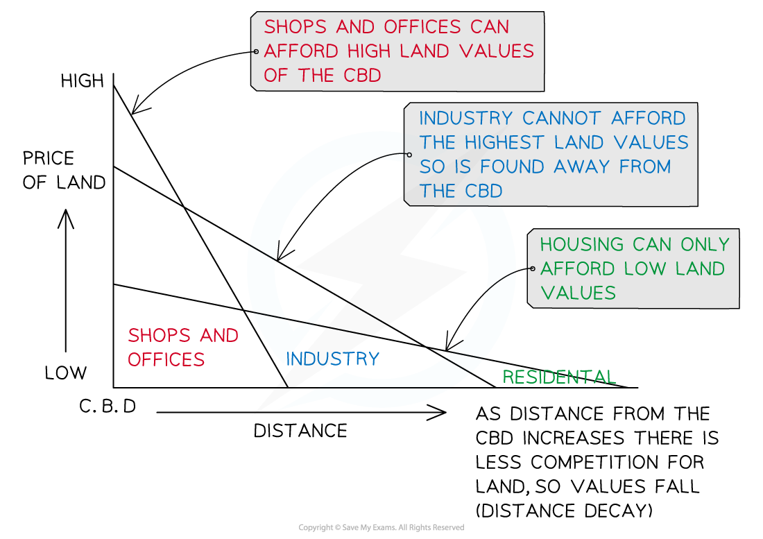
Bid-rent graph shows land prices decrease further from the CBD
Urban land use in LEDCs
-
The Latin American city model shows that the CBD has developed around a colonial core, with a commercial corridor extending from it
- This has become the main avenue and contains open spaces and homes for medium- and higher-income earners
- These areas will have quality streets, schools and public services
-
Newer suburbs are found further out with random housing and fewer services
-
Squatter housing is found at the edge of the city; however, the more established squatter settlements can be found along the zones that extend into the city centre
- Conditions here are usually better than in the more recent housing at the edge, most likely due to employment opportunities found closer to the core
-
Industrial areas are scattered along the major transport routes, with the newest developments at the edge
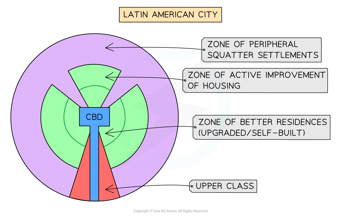
Latin American city model
Land zoning in LEDCs
- Manufacturing is found throughout the city
- Segregation is seen through wealth, ethnicity and race
- The wealthy are found closer to the central core of the city on wealthy land
- The poor are pushed to the peripheral areas
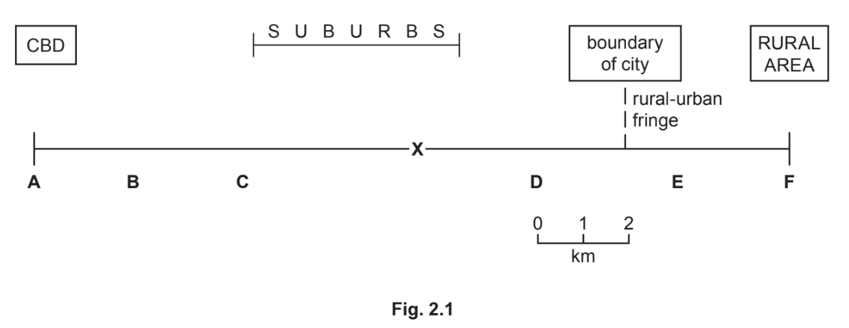
Worked Example Study Fig. 2.1, which is a transect across a city in Belgium, an MEDC in Europe.
(i) What is the distance from the CBD to the boundary of the city?
........................km
[1 Marks]
Answer: **
Final answer:** Approximately 13 km from CBD to fringe **
Use a ruler and measure the distance key, which tells you that so many cm = 1 or 2 km; in this instance, it is 0.5 cm = 1 km and 2 km = 1 cm
Measure the length from A to boundary between D and E = 6.5 cm (approx.)
6 x 2 = 12km plus 1km for the 0.5 cm = 13km from CBD to fringe approximately
(ii) Identify from Fig. 2.1 the letter which represents:
- an area of traditional industry where redevelopment is taking place**= B
- an area where a ring road and business park have recently been built on greenfield sites **= E
[2 Marks]
(iii) State three likely differences between residential areas C and D in the MEDC city shown in Fig. 2.1.
[3 Marks]
Final answer:** Answer **
** **D is likely to:
- Be newer
- Have a lower density
- Be higher in cost
- Have detached/semi-detached houses rather than terraced/semi-detached
- Rather than detached
- Have gardens/drives/garages, etc.
(iv) Give two examples of low-order services that are likely to be located close to residential areas, such as in area X in Fig. 2.1.
Explain why many of the services in this area are likely to be low-order services.
[4 Marks]
Final answer: Possible answers:
-** Services **such as:
newsagent
general store
grocers
primary school
church etc.
Reasons such as:
- a small sphere of influence
- people will not travel far to use them
- threshold population will be small
- lots of similar services
- will be used frequently
- sell convenience goods, etc.
** NB: 2 Marks max for each of the examples and reasons
Was this revision note helpful?
Build on this topic