Reducing the Impact of Earthquakes & Volcanoes (Cambridge International IGCSE Geography)
Reducing the Impacts of Earthquakes & Volcanoes
Spec point —
2.1.6· Explain what can be done to reduce the impacts of earthquakes and volcanoes
-
The responses to earthquakes and volcanic eruptions can be short-term or long-term
- Short-term responses are those which happen straight after an event and include aid and disaster relief
- Long-term responses aim to reduce the impact of future hazardous events and include risk assessments and hazard mapping
Earthquakes: long-term responses
-
Accurate prediction of earthquakes is not currently possible, but monitoring is
-
Many different methods of monitoring are being used to help research possible prediction methods, including:
- tiltmeters, which monitor ground changes
- clusters of small earthquakes
- changes in radon gas emissions
- changes in animal behaviour
- remote sensing of ground movement using satellites
-
In developed countries, building design and engineering are commonly used to reduce the impact of earthquakes
-
Building regulations and codes require new buildings to include earthquake-resistant features, including:
- shutters on windows prevent falling glass
- cross-bracing or diagonal bracing of steel frames
- flexible building materials
- foundations sank deep into the bedrock
- frames which sway with the earthquake tremors
- rubber shock absorbers to reduce tremors moving through the building
- reinforce walls/pillars with concrete
- Shatterproof/reinforced glass
- fire-resistant materials
- automatic cut-off for gas/electricity
-
In many countries, earthquake drills are regularly carried out
- The drills help people prepare for what to do in an earthquake to protect themselves
-
Education about how to prepare homes means that people are less likely to be injured by falling objects and furniture
Volcanoes and earthquakes: long-term responses
-
There are some examples of planning which are used in both areas vulnerable to earthquakes and those vulnerable to volcanic eruptions
-
In vulnerable areas:
-
Remote sensing of the Earth's surface by satellites such as Sentinel 1 provides data about changes in ground movement
-
Geographic Information Systems (GIS) provides layers of data such as:
- vulnerable areas
- land use
- infrastructure such as roads
-
GIS data is then used to assist with land use planning
-
Land Use Planning
- Mapping of areas most at risk from earthquakes
- Planning can ensure that valuable services such as the fire service and hospitals are not built in high-risk areas
- Densely populated housing can be located away from high-risk areas
-
Worked Example Explain how new buildings can be earthquake-proofed so they are less likely to be damaged in an earthquake.
[4 Marks]
Final answer: Answer
- Build deep/stronger/sturdier foundations/base [1]
- Reinforce/use concrete/bricks for buildings/walls/roofs [1]
- Use metal, steel, and aluminium beams [1]
- Use diagonal bracing [1]
- Flexible building materials [1]
- Use dampers/shock absorbers in the base of the building [1]
- Computers controlled weights/counterbalances on roof/weight on the roof [1]
- Automatic window shutters [1]
- Shatterproof/strong/reinforced glass [1]
- Use fire-resistant materials [1]
- Build low building/do not build high rise [1]
- Use automatic cut-off for gas pipes/electricity cables [1]
Case Study: Nepal
Spec point —
2.1.6· An Earthquake
Case Study
- Nepal is one of the poorest countries in the world, with a Gross Domestic Product (GDP) per capita of under $1000
- Located between China and India, Nepal is a landlocked country
- In 2015, 80% of the population lived in rural, often remote, communities
Earthquake, April 2015
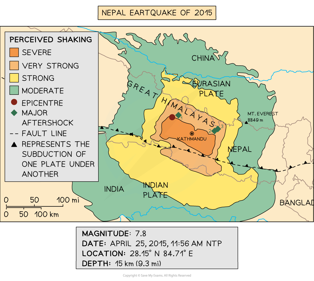
- In April 2015, at 11.26 am, Nepal was struck by an earthquake, magnitude 7.8
- The epicentre was 80 km northwest of Kathmandu in the Gorka district
- The focus was shallow at only 15 km beneath the surface
- Over 300 aftershocks followed the main earthquake
Location of Nepal's earthquake
Cause
- Nepal is located on a collision boundary between the Indian and Eurasian plates
Effects
- Approximately 9000 deaths
- Over 20,000 people injured
- Electricity and water supplies cut
- 7000 schools and 1000 health facilities were damaged or destroyed
- Almost 3.5 million people were made homeless
- Offices, shops and factories were destroyed, meaning people were unable to make a living
- UNESCO World Heritage were sites destroyed as well as many temples
- Loss of tourist income, which Nepal is reliant on
- Avalanches on Mount Everest and in the Langtang Valley
- Landslides which blocked roads and rivers
- Damages estimated at between $7 and $10 billion, about 35% of the GDP
Immediate responses
Donations of money and aid from around the world totalled $3 billion, including $3.3 million from China and $51 million from the UK
Many countries sent aid in the form of:
- temporary shelters
- medicines
- food
- water
- clothing
- search and rescue teams
- medical staff
Approximately 90% of the Nepalese army was mobilised
Tent cities were set up in Kathmandu for those made homeless
GIS crisis mapping tool was used to coordinate the response
A $3 million grant was provided by the Asian Development Bank for emergency relief
Long-term response
- Landslides were cleared and roads repaired to restore access to remote rural communities
- Schools were rebuilt
- Earthquake drills were introduced to provide people with education about what to do in the event of an earthquake
- Stricter building codes with more enforcement
- About $200 million was provided by the Asian Development Bank for rebuilding
- A new government task force was set up to plan for future earthquake events
Case Study: La Palma
Spec point —
2.1.6· A Volcano
Case Study
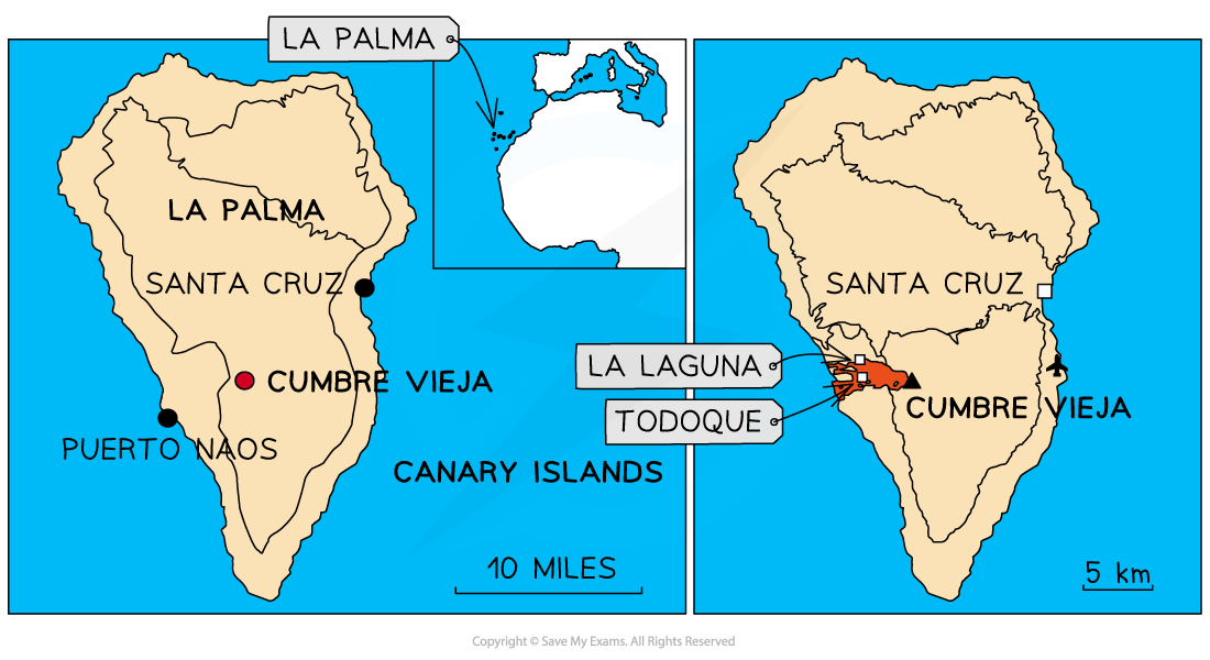
- Part of the Canary Islands, La Palma is located in the Atlantic Ocean off the coast of North Africa
- The Canary Islands are an autonomous region of Spain
- There are 33 volcanoes across the Canary Islands, 10 of which are in La Palma
- La Palma has a population of 85,000
Eruption, September 2021
- The Cumbre Viejo volcano on La Palma began to erupt on September 19, 2021 and the eruption lasted for almost three months
- The eruption was VEI 2 to VEI 3
Location of the Cumbre Vieja eruption
Cause
- La Palma and the other Canary Islands are located on the African plate
- The islands are an archipelago which has formed as the result of a hot spot
- This means that they are not located on a plate boundary but over a magma plume
Signs of eruption
- Deformation of the mountain indicated rising magma about a week before the eruption
- Between 10 and 19 September, there were over 25,000 earthquakes—an 'earthquake swarm'
Effects
- Over **7,000 **people had to be evacuated from their homes
- Almost **1,500 houses **were destroyed by the lava flow
- Over 1,500 other buildings, such as churches, shops, and schools, were destroyed
- The lava flow cut across the coastal highway
- The water supply was cut off for almost 3,000 people
- 400 hectares of banana farms were destroyed
- Almost 1,300 hectares of land were effected
- 1 death
- About 20,000 people were exposed to the eruption and its effects
- Air traffic disruption
- €1 billion damages
Immediate response
- A warning was issued of an eruption on 13th September and 40 people and livestock were evacuated
- A further 1000 people were evacuated after the eruption began on the 19th September
- 5600 more people were evacuated over the next few weeks
- The alert level was raised to red
- Air traffic was briefly suspended
- Constant monitoring of lava flow and gas emissions to ensure the safety of the population
- Food and shelter were provided for those made homeless
- A** €5.4 million** advanced payment donated by the** EU**
Long-term response
- Spain promised €400 million to La Palma for rebuilding
- Prefabricated housing was built for those made homeless but six months on, many people were still living in hotels and with family and friends
- Constant monitoring of the volcano and others on La Palma
- Improved crisis management processes are now in place for future eruptions
Was this revision note helpful?
Build on this topic