Preparing for Earthquakes (Edexcel IGCSE Geography)
Warning & Evacuation
Spec point —
4GE1-S3.044
-
Accurate prediction of earthquakes is not currently possible but monitoring is
-
Many different methods of monitoring are being used to find possible prediction methods:
- Tiltmeters- which monitor ground changes
- Clusters of small earthquakes
- Changes in radon gas emissions
- Changes in animal behaviour such as toads
- Remote sensing of ground movement using satellites
Building Design & Preparation
Spec point —
4GE1-S3.044
-
Countries can prepare for earthquakes in several ways:
- Building design and earthquake-resistant structures
- Land use planning
- Earthquake drills
- Emergency planning
Building design
-
In developed countries building design and engineering are commonly used to reduce the impact of earthquakes
-
Building regulations and codes require new buildings to include earthquake-resistant features:
- Shutters on windows prevent falling glass
- Small windows
- Reinforced walls
- Cross-bracing of steel frames
- Foundations sunk deep into the bedrock
- Frames which sway with the earthquake tremors
- Rubber shock absorbers to reduce tremors moving through the building
Land use planning
- Land use mapping involves mapping areas most at risk from earthquakes
- Once the areas are mapped planning can ensure that valuable services such as the fire service and hospitals are not built in high-risk areas
- Densely populated housing can also be located away from high-risk areas
Drills and education
-
In many countries, earthquake drills are regularly carried out
-
The drills help people to prepare for what to do in an earthquake to protect themselves
- People are more likely to survive if they know what to do in the event of an earthquake
- Drop, cover and hold on is the advice given to people to protect themselves if indoors
-
Education about how to prepare homes means that people are less likely to be injured by falling objects and furniture
Remote Sensing & GIS
Spec point —
4GE1-S3.044
Remote sensing and GIS
-
Remote sensing of the Earth's surface by satellites such as Sentinel 1 provides data about changes in ground movement
-
Geographic Information Systems (GIS) provides layers of data such as:
- vulnerable areas
- land use
- infrastructure such as roads
-
GIS data is then used to assist with land use planning
-
The data can also be used by emergency services to manage the impacts of earthquake including:
- the risks to population, buildings and infrastructure
- recommending mitigation for future earthquakes
- search and rescue prioritisation
- informing decisions about where resources should be directed
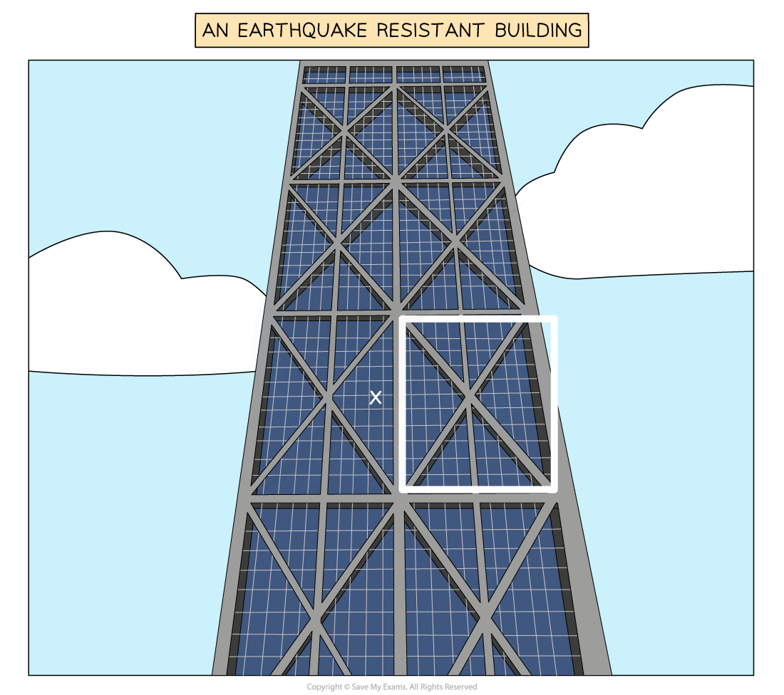
Worked Example Study Figure 1b which shows an earthquake-resistant building
Identify the element of building design in box X which makes it earthquake resistant
(1 Mark)
Answer
The feature identified in the image is the cross bracing which makes the building less likely to collapse. Any of the following answers would be accepted
- Cross bracing (1)
- Reinforced concrete (1)
- Concrete exoskeleton (1)
Exam Hint Remember with earthquakes preparation is essential because at the moment they are impossible to predict.
Case Studies: Nepal & Japan
Spec point —
4GE1-S3.044
Case Study
Nepal - A developing country
- Nepal is one of the poorest countries in the world
- GDP per capita in 2015 was US$3,332
- The country is **politically unstable **with a civil war between 1996 and 2006
- Earthquake experts view Kathmandu as one of the most dangerous places in the world in terms of earthquake risk
Preparations before the 2015 earthquake
In 1997 the Nepali government created the** Kathmandu Valley Earthquake Risk Management Project (KVERMP)** this included;
- The School Earthquake Safety Programme (SESP) provided funding to schools for earthquake drills
- Training to make buildings more resistant to earthquakes
- Earthquake Safety Day
Allocation of 83 open spaces around Kathmandu to be used as camps for displaced populations where they would be supplied with shelter, food and medical services
Improved the 1994 National Building Code and trained building inspectors
In 2009, the government set up a National Strategy for Disaster Risk Management
In 2010 a National Emergency Operations Centre was set up to coordinate the humanitarian response and restoration of the infrastructure
Nepal Red Cross Society maintained 12 warehouses with stocks of emergency supplies
Issues with the preparations
- The earthquake education was mainly in urban areas so people in rural areas did not have drills or knowledge about what to do when the earthquake struck
- There are 121 recognised languages as well as Nepali (the official language) which are spoken in Nepal this makes communication of earthquake advice and education difficult
- There were not enough emergency supplies to begin with
- The building code was often ignored and so many buildings were still not earthquake-resistant
- Due to political instability, the national strategy and operations centre were not as effective as they should have been
- The emergency supplies of the Nepal Red Cross were not enough for the scale of the disaster
Case Study
Japan - A developed country
- Japan is one of the wealthiest countries in the world
- GDP per capita in 2011 was US$48,168
- Japan is one of the most seismically active places in the world with 20% of earthquakes over magnitude 6.0 happening there
Preparations before the 2011 earthquake
Earthquake drills are practiced regularly so that people know exactly what to do during an earthquake event and immediately afterwards
Households are encouraged to have an emergency survival bag packed and ready at all times
Many buildings are designed to be earthquake-resistant
- Building codes were further tightened after the Kobe earthquake in 1995
- Over 80% of buildings in Tokyo are earthquake-resistant
Sea walls between 3-10m built in some coastal areas
Breakwaters off the coast at Kamaishi and Ofunato Bay
Trains automatically stop when an earthquake is detected, to avoid derailments
Nuclear power stations automatically shut down
There is a tsunami warning service with 180 seismic stations and 80 water-based sensors
Warnings are issued via
- phone
- television
- sirens
- loudspeakers
The warning system costs about US$20 million a year
Issues with the preparations
- People did know exactly what to do in the earthquake but were not as prepared for the tsunami
- Many people do not have an emergency survival bag
- Many buildings survived the earthquake but not the tsunami
- The tsunami overtopped the sea walls
- There was an issue restoring the cooling system at the Fukushima nuclear power plant leading to radioactive contamination in the surrounding area
- People ignored the tsunami warning as they thought they would be protected by the sea walls
Was this revision note helpful?