Impacts of Natural Hazards (Edexcel IGCSE Geography)
Spec point —
4GE1-S3.044
Impacts of natural hazards
- Natural hazards have both short- and long-term impacts
Short-term impacts
-
Short-term impacts are the things that affect people in the days and weeks after a hazard event
-
They include:
- damage to properties from high wind, heavy rain and storm surges, power cables and telephone lines
- impact on businesses, tourism and transport
- landslides
- deaths and injuries
- a decrease in quality of life
- crops destroyed, impacting farmers' incomes and increasing food prices
- habitat destruction
Long-term impacts
-
In the months and years after a hazard event, there are long-term impacts, including:
- rebuilding of homes, schools, infrastructure and businesses can take time
- the cost of rebuilding affects the economy, increases unemployment
- stricter building codes introduced
- mental health, Post Traumatic Stress Disorder (PTSD)
- risk assessments and hazard mapping are reviewed
Exam Hint
- In the exam, you may be asked to analyse the short- and long-term impacts of an earthquake event. In your answer, you need to consider: Why short- and long-term impacts vary – the size and magnitude of the event
- What are the main short- and long-term impacts
- How the impacts are affected by the level of development, location and accessibility of the area
- What are the knock-on effects of some impacts e.g. water supplies being contaminated can lead to disease
Case Study: Impacts of Tropical Cyclones
Spec point —
4GE1-S3.044
Case Study
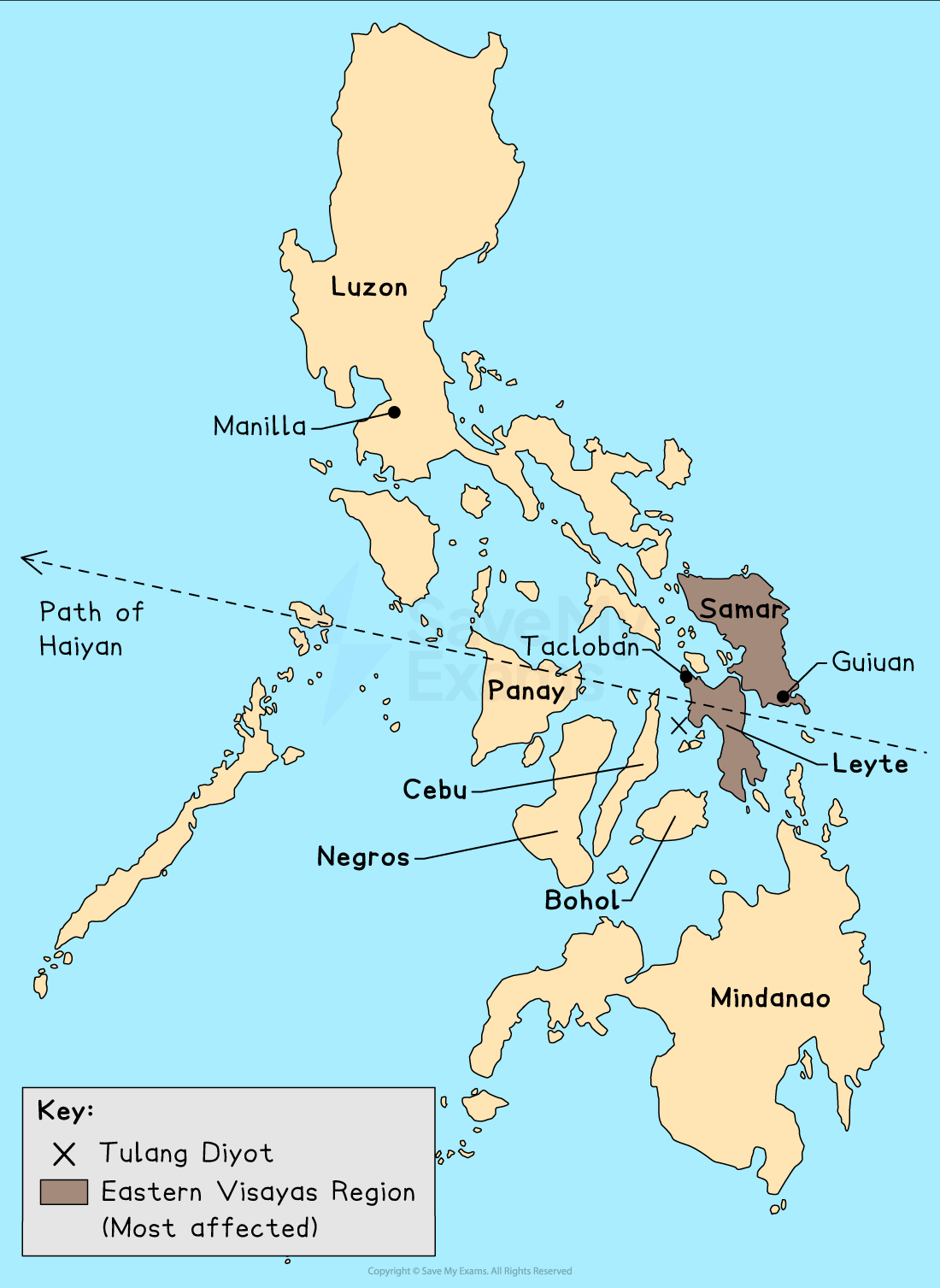
Tropical cyclone Haiyan
- Name – Haiyan (Yolanda)
- Location – Philippines, Vietnam and Taiwan
- Date - November 2013
- Magnitude - Category 5
- Highest wind speed – 315 km/h
- Storm surge - up to 6 m
- **Rainfall **– 282 mm in 12 hours
Path of Tropical Cyclone Haiyan (Yolanda)
Short-term impacts
An estimated 6400 deaths
Over** 4.1 million** people made homeless
Almost 90% of Tacloban was destroyed
Roads blocked by debris and landslides
Electricity supply was down in some areas for six weeks
The airport at Tacloban was badly damaged
Agriculture was affected by:
- over 1.1 million tonnes of crops destroyed
- at least 33 million coconut trees destroyed
More than 1.1 million homes were damaged or destroyed
The cyclone affected 14 million people
Land-slides
Long-term impacts
The cost totalled US$5.8 billion
**'Build Back Better' was **launched in 2014 to upgrade buildings to reduce the damage from future tropical cyclones
- By 2016 only 1% of the target of 200,000 homes had been achieved
A no-build zone was created along the** Eastern Visayas** coastline
A storm surge warning system was implemented
Mangroves replanted
Tropical storm shelters built inland
One year on, 4 million people were still in temporary shelters
Six months later in Tacloban access to clean water was still limited
Case Study: Impacts of Earthquakes
Spec point —
4GE1-S3.044
Case Study
Gorkha earthquake
- Name- Gorkha
- Location– Nepal
- Date- 25th April 2015
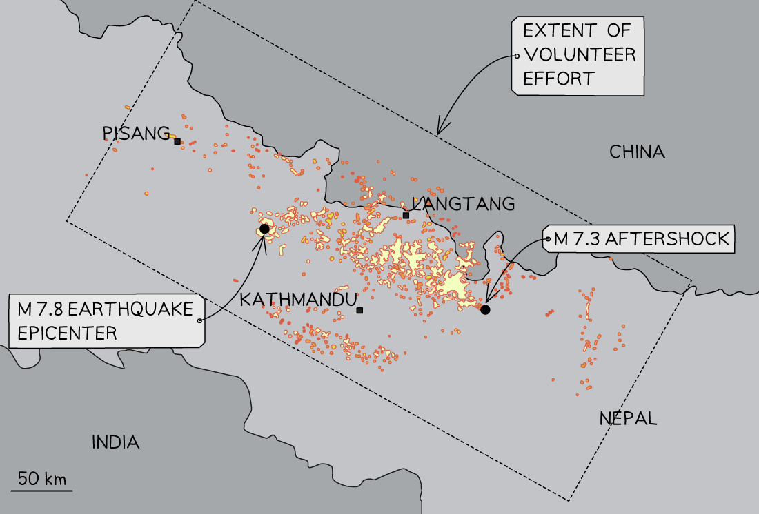
- **Epicentre **– Barpak village, 60km north-west of Kathmandu (capital)
- **Depth **– 15 km
- **Magnitude **- 7.8
- Plate boundary – Collision plate where Indian plate collides with the Eurasian plate
Landslides triggered by the Gorkha earthquake
Short-term impacts
- Approximately 8600 deaths
- Over** 19,000 injuries**
- Avalanches on Mount Everest and in the** Langtang Valley**
- Roads blocked due to landslides
- Landslides – the village of Ghodatabela covered, leading to 250 deaths
- Over** 600,000 houses** were destroyed and over **250,000 **damaged
- UNESCO World Heritage sites destroyed – Changu** Narayan Temple and Dharahara Tower**
- Approximately, 8,300 schools were damaged or destroyed
- Over **1,000 health centres **destroyed
Long-term impacts
- The cost of repairs were over US$10 billion
- Over 7000 schools rebuilt
- Two years later** 70%** of displaced people are still in temporary shelters
- Stricter building codes introduced – but not always enforced
- Asian Development Bank (ADB) provided a US$3 million grant
- Grants of US$3000 for people to rebuild homes – many have not repaid this 5 years later
Case Study
Kaikōura earthquake
- Name– Kaikōura
- Location- New Zealand
- Date– 14th November 2016
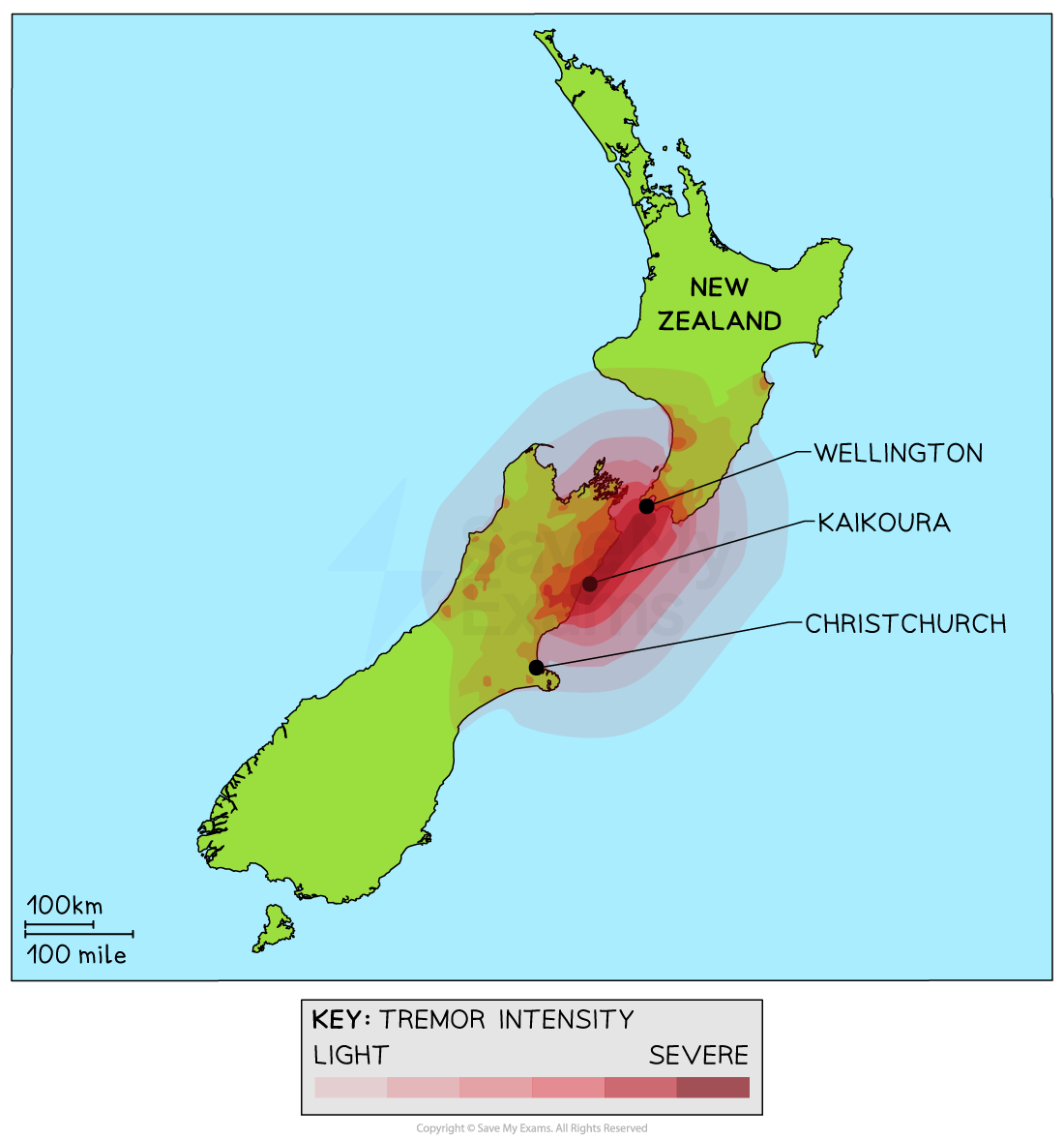
- Epicentre– 15km north-east of Culverden and 60km south-west of Kaikōura
- Depth– 15 km
- Magnitude- 7.8
- Plate boundary – destructive boundary between the Indian-Australian and Pacific plates
Location of the Kaikoura earthquake
Short-term impacts
Two deaths
Over 50 people injured
Temporary homelessness of 60 people
Over 2000 buildings were damaged or destroyed, including some in the capital city, Wellington
Power, water and telecommunication cut off to Kaikōura and surrounding communities
Approximately 11,000 landslides:
- Destruction of 390km of road and railway
- Kaikōura and surrounding communities were completely cut off for 16 days
Uplift of the coastline by 5.5 metres in some areas:
- Kaikōura's harbour was affected by the uplift, meaning boats could not leave or enter the harbour
- Disruption of the coastal breeding areas for dolphins, seals and seabirds
A tsunami followed the earthquake, reaching up to 6.9 metres in Goose Bay
Insurance costs reached $2.27 billion
The cost to the government reached almost $3.5 billion
Long-term impacts
- Improvements to the tsunami warning procedure
- Road routes were repaired between one month and one year after the event
- The main rail route reopened after two months but full repair took over a year
- Improvements to the building regulations made to assess existing buildings for earthquake resistance
- Kaikōura's harbour was rebuilt; taking over a year to complete
Case Study: Impact of Volcanoes
Spec point —
4GE1-S3.044
Case Study
Mount Merapi eruption
- Name - Mount Merapi
- Location - Java, Indonesia
- Date: 25th October - 30th November 2010
- Magnitude - VEI 4
- Plate boundary– A destructive plate boundary where the Indo-Australian plate is subducting below the Eurasian plate
- **Type of volcano **– stratovolcano or composite
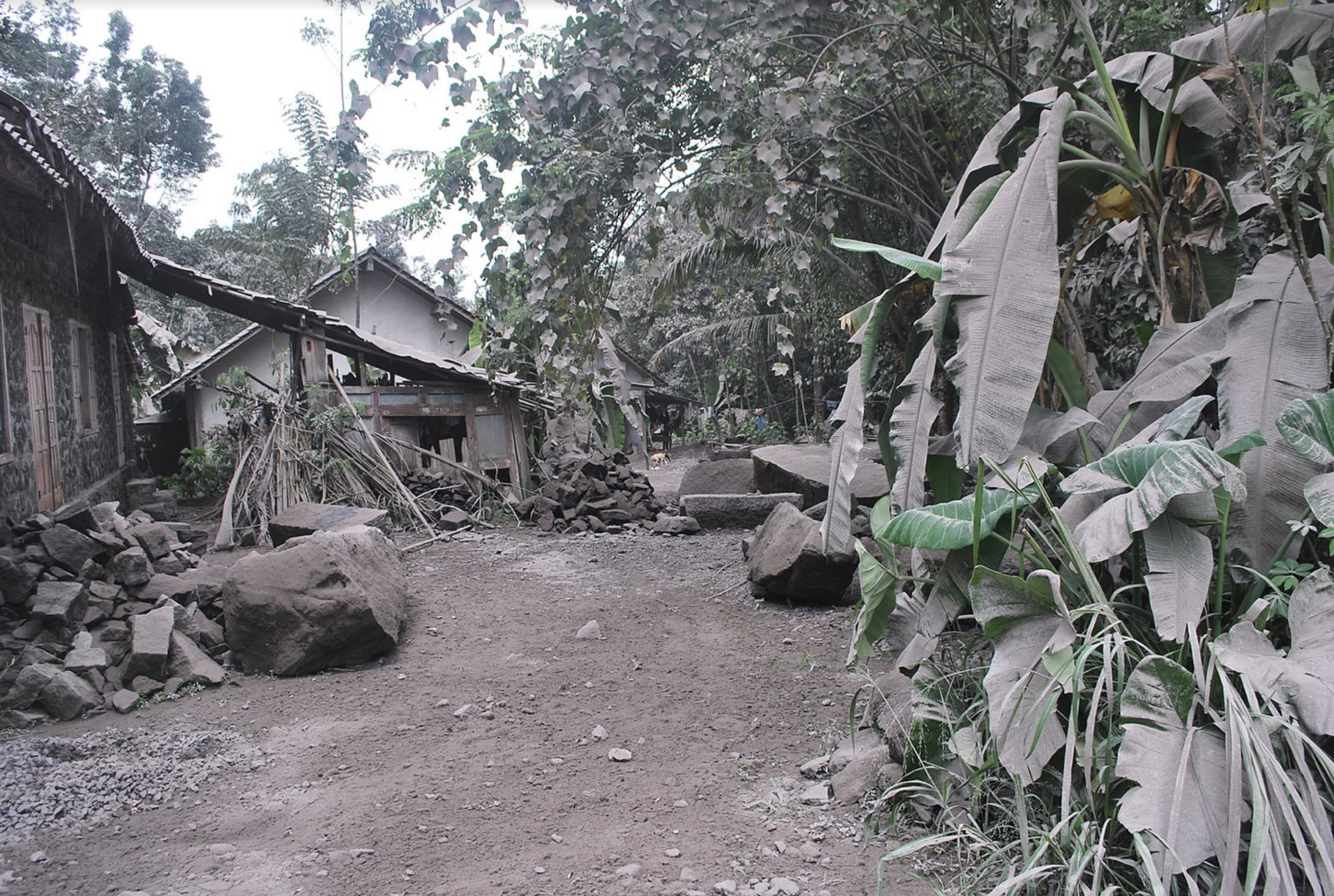
Ash fall on village near to Mount Merapi
Short-term impacts
- There were** 353 deaths** and 577 injuries
- Pyroclastic flow travelled 3km
- Volcanic ash fell up to 480km away
- Over **30cm **of ash covered nearby villages, including Bronggang 15km from the volcano and Yogyakarta
- The exclusion zone extended to 20km
- Roads blocked
- Food prices increase
- Approximately, 350,000 people evacuated
- Schools and airports closed
- Lahars
- Decrease in tourism income
Long-term impacts
- The hazard map was updated and the exclusion zone expanded permanently to** 2.5km**
- Over 2,500 residents moved to permanent new homes
- Money given to farmers by the government to replace livestock and crops
- Improved monitoring
- Increased education to inform people of what to do and where to go in the event of another eruption
- Dams built to hold back lahars
- Soils will be more fertile due to the minerals contained in the falling ash
Exam Hint Remember, whether you use the case studies here or ones you have completed in class, in the exam you will be expected to know some facts and figures from case studies. These are place-specific details and are what the examiner will be looking for in higher-level answers.
Was this revision note helpful?