The Drainage Basin (Edexcel IGCSE Geography)
Spec point —
4GE1-S3.042
What is a drainage basin?
-
A drainage basin is the area of land drained by a river and its tributaries
- This is also known as the catchment area of the river
-
Drainage basins are open systems
-
As well as stores and transfers drainage basins have inputs and outputs
- The input is any water entering the system (precipitation)
- Outputs are where water is lost from the drainage basin (evaporation, transpiration and into the sea/lake)
-
When precipitation falls into the drainage basin it will take different paths. These include:
- direct channel precipitation which occurs when the water falls directly into a river
- overland flow (surface runoff) when the water cannot infiltrate the soil due to the ground being impermeable
- throughflow when the water flows through the soil
- groundwater flow when the water flows through the rocks
-
Every drainage basin is unique
-
They have different:
- shapes
- sizes
- rock types
- relief
- land use
Drainage basin features
-
All drainage basins have some features in common:
-
The watershed is the boundary between drainage basins
-
A source is the point of the river which is furthest from the mouth; this is the point at which the river begins and is usually an upland lake, spring or glacier
- Gravity then causes water to flow downhill, taking the fastest and easiest path
-
A confluence is the place where two or more streams/rivers meet
-
Tributaries are streams or rivers flowing into larger streams or rivers
-
The mouth of a river is where it enters the sea/ocean or sometimes a lake
-
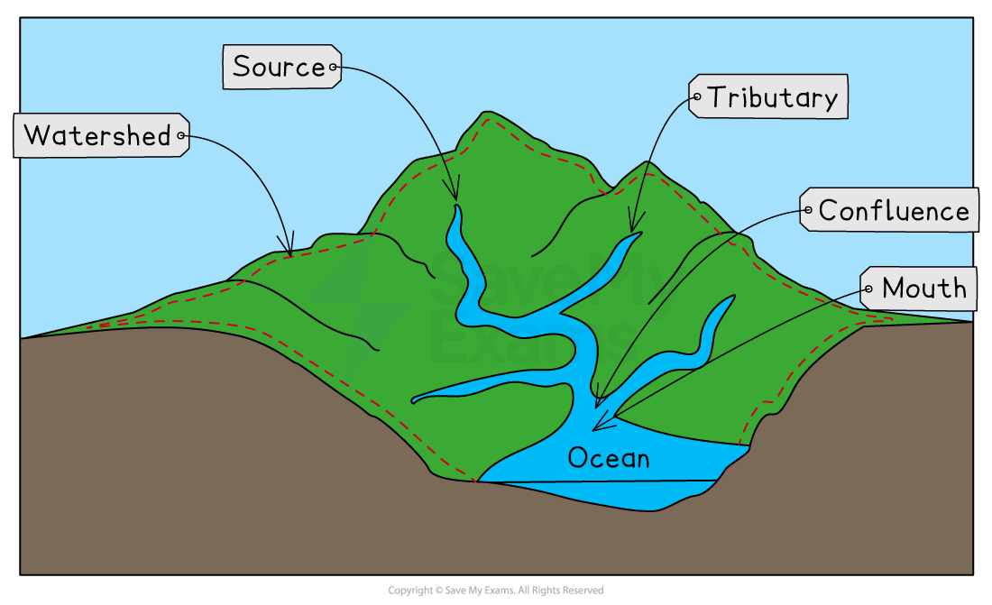
The main features of a drainage basin
Channel network
-
The channel network consists of the main river channel and all of its tributaries
-
Every drainage basin is covered by a network of tributaries which connect to the main river channel
-
The number of tributaries in a drainage basin is referred to as the drainage density:
- Drainage basins with lots of tributaries have a high drainage density
- Drainage basins with few tributaries have a low drainage density
-
The drainage density is the result of the soil and rock under the surface
-
Where the rock or soil is impermeable this leads to high drainage density because the water cannot infiltrate
- This means it flows over the surface in tributaries
-
Where the rock or soil is permeable water can infiltrate leading to low drainage density
Exam Hint You need to ensure that you are clear about the difference between a closed system such as the hydrological cycle and an open system such as a drainage basin. Remember a closed system has no inputs or outputs whereas an open system has both inputs and outputs.
Was this revision note helpful?