River Regime & Hydrographs (Edexcel IGCSE Geography)
River Regimes & Storm Hydrographs
Spec point —
4GE1-S3.042
River regimes
-
The discharge of a river is defined as the amount of water passing a specific point on the river at a given time
-
Discharge changes over time
- The river regime is a record of these changes over a year
-
Many factors can influence the river regime including:
- climate
- vegetation
- land use
- geology
- soil
- human activity
- drainage basin size and shape
- drainage density
- relief
Storm hydrographs
-
A storm hydrograph shows the changes in river discharge after a storm event
-
The graph shows a short period, usually 24 hours
-
The storm hydrograph has several features:
-
Base flow which is the 'normal' level of river discharge
- The water mainly comes from groundwater flow
-
Peak rainfall is the highest rainfall level during the storm
- The time of the peak rainfall is taken from the centre of the bar
-
The rising limb shows the increase in the river discharge
- The steeper the limb the faster the river discharge has increased
-
Peak discharge or peak flow is the highest level of discharge
-
Lag time is the time difference between the peak rainfall and the peak discharge
- The shorter the lag time the higher the risk of flooding because the river may not have the capacity to contain the increase in discharge
- Where there is more overland flow (surface runoff) the lag time will be shorter
-
The recessional limb shows the river discharge returning to normal flow
- The steeper the recessional limb is the faster the river returns to normal flow
-
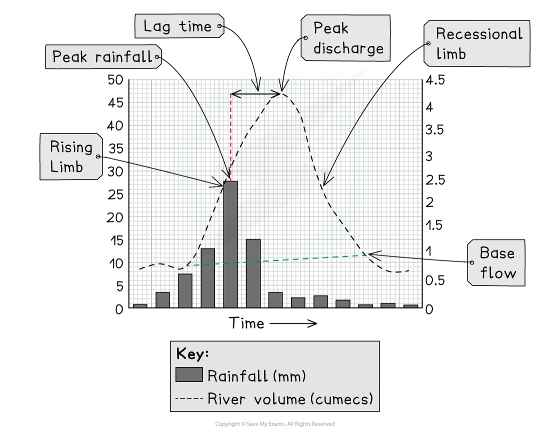
Storm hydrograph in an urban area
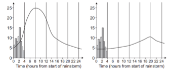
Worked Example Study Figure 1, which shows storm hydrographs for rivers A and B
River A River B
Figure 1 Storm Hydrographs
What is the lag time for river A? (1)
To work out the answer, you need to calculate the difference between the peak rainfall and peak discharge:
- The peak rainfall is between 2 and 3 hours from the start of the storm; taken at the midpoint, this would be 2 hours and 30 minutes.
- The peak discharge is at 8 hours from the start of the storm
- 8 hours - 2 hours and 30 mins = 5 hours and 30 mins
Final answer: Answer
Lag time = 5 hours and 30 mins (1)
Exam Hint Remember, a storm hydrograph shows the changes in discharge over a short period after a storm event, whereas the river regime shows changes in discharge over a long period, usually a year.
Factors Affecting Regimes
Spec point —
4GE1-S3.042
-
There are many factors which affect the discharge or regime of a river
-
The shape of storm hydrographs is also affected by these factors
-
Factors which increase overland flow (surface runoff) lead to:
- shorter lag times
- increased discharge
- steeper rising limb
Climate
- Snow and ice melt leads to higher discharge – usually in the spring months
- High temperatures increase evaporation and reduce river discharge
- Higher rainfall, often in autumn and winter, increases river discharge
- Convectional rainfall in summer or hot, moist climates increases river discharge
Vegetation
- Vegetation increases interception and infiltration, leading to reduced overland flow and so lower river discharge
- Deciduous trees lose their leaves in winter, decreasing interception and increasing overland flow and river discharge
Land use
-
Concrete and tarmac in urban areas and built environments are impermeable, leading to high overland flow
- This is rapidly taken by drainage systems to the rivers/streams, increasing river discharge
Geology
- Permeable rocks increase infiltration and percolation, which reduces overland flow and decreases river discharge
- Impermeable rock decreases infiltration and percolation; this increases overland flow and river discharge
Soils
- Soils which are compacted or frozen reduce infiltration, increasing overland flow and river discharge
Abstraction
- Water taken for irrigation and domestic use decreases the river discharge
Dams
- Dams control the flow of water, so can both increase and decrease river discharge
- Reservoirs experience higher levels of evaporation which can decrease river discharge
Relief
- Steep slopes increase overland flow because the water is moving fast, reducing infiltration; this leads to increased river discharge
Drainage density
- High drainage density leads to increased discharge, particularly after a rainfall event
Exam Hint Remember, all the factors which affect river regimes also affect the risk of flooding. Any factor which increases overland flow and discharge also increases the risk of flooding.
Was this revision note helpful?