Rural Enquiry Skills (Edexcel IGCSE Geography)
The Rural Fieldwork Report
Spec point —
4GE1-S9.128
The fieldwork report
Rural environment enquiry data presentation
- Data presentation can take many forms
Primary data
-
Much of the primary data collected in a rural environment enquiry will be presented in the form of graphs:
- Each type of graph is suitable for particular data sets
- The graphs may have strengths and limitations
-
Suitable graphs include:
- Bar graphs to compare the environmental quality scores at different sample sites
- Compound or divided bar graphs to show traffic counts
- Scattergraphs to show the relationship between factors such as proximity to land use change and the environmental quality of a site
- Rose diagrams to show noise levels
-
Data presentation may also include maps:
- Sample site location
- Proportional circle maps to show traffic counts at different sample sites
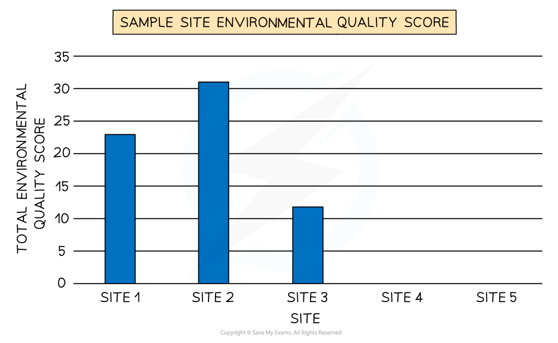
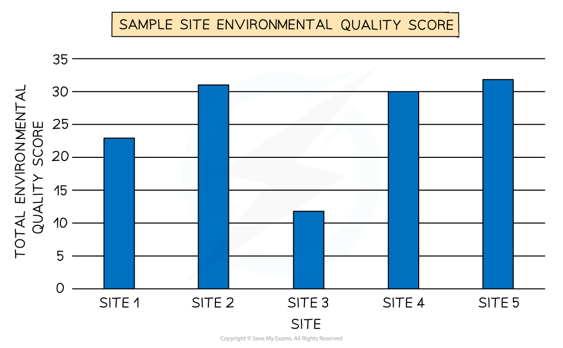
Worked Example Study Figure 1a shows the results of an environmental quality survey around a new industrial development in a rural area
Complete Figure 1b for sites 4 and 5
(2 Marks)
Site Environmental Quality Survey Score 1 23 2 31 3 12 4 30 5 32 Figure 1a Environmental Quality Survey Score Data
Answer:
- The first bar needs to be just above the 30 line and the second line needs to be on the 35 line. The bars do not need to be shaded but should be the same width as the other bars (2)
Identify the site which has the highest environmental quality score
(1 Mark)
Answer:
- Site 5 with a score of 32 has the highest environmental quality score (1)
Exam Hint In the exam, you will not be asked to draw an entire graph. However, it is common to be asked to complete an unfinished graph using the data provided. You may be asked to identify the highest or lowest score or an anomalous result. When completing a graph:
Take your time to ensure that you have marked the data on to the graph accurately
Use the same style as the data which has already been put on the graph:
- Bars on the graph should be the same width
- If the dots on the graph are connected by a line, then you should do the same
Secondary data
-
Any fieldwork should include secondary data as well as primary data
-
In a rural environment enquiry suitable data may include:
- Historical traffic counts
- Maps of the area where the land use change has occurred
- Newspaper articles/websites about the land use change
- Aerial photographs
Worked Example You have studied rural environments as part of your own geographical enquiry
**(i) State one type of secondary data that you used in your geographical enquiry **
(1 Mark)
Answer:
- Newspapers (1)
- GIS map/paper map** (1)**
- Textbook/magazine (1)
- Government report/policy document **(1) **
- Blog/website/social media (1)
- Census data (1)
- Old photographs (1)
(ii) Explain one way this secondary data helped you when investigating rural environments
(2 Marks)
Answer:
- Census data about the village's population meant we knew the population structure** (1)** so we could design a fair sampling frame for the questionnaire about the land use change (1).
- Historical photographs enabled us to see the site before the land use change (1) so we could compare it to the current land use (1)
- Website and social media included lots of views and opinions about the land use change (1) so we could use these together with our questionnaire data (1)
Analysing & Interpreting Rural Data
Spec point —
4GE1-S9.128
Analysing & interpreting data
-
Once all the data has been collected and presented, it needs to be analysed
-
The data which is collected regarding rural environment change, such as environmental quality surveys and traffic counts, is quantitative data
- These will be analysed using statistical methods
-
One of the main statistical methods that may be used is the mean
Worked Example **Calculate the range in environmental quality survey scores **
(2 Marks)
Site ** Environmental Quality Survey Score** 1 23 2 31 3 12 4 30 5 32 Show your workings
Answer:
- Award 1 mark for the calculation of the correct answer = 10 (1)
- Award 1 mark for correct method to calculate range = 32-12 (1) or working out with similar numbers, i.e., understanding idea of difference/subtraction (highest and lowest values)
Analysing photographs and field sketches
-
The use of photographs and field sketches is qualitative analysis
-
Photographs and field sketches can be used in a rural environment enquiry to analyse several different features:
- different land use features at the sample sites
- data collection techniques
- images of land-use changes – new housing/road/industry
Worked Example **Explain two methods you used to analyse some of your fieldwork data **
(4 Marks)
Answer:
- Quantitative tools such as mean and median** (1)** so we could final measures of centrality in our data (1)
- Annotated sketches based on photographs from the fieldwork were used **(1) **and the selected annotations were able to highlight characteristics and processes (1)
- A computer spreadsheet was used to calculate the spread and range in our questionnaire data (1) so that we could compare the outcomes between different sample sites** (1)**
Conclusion
-
Once the data has been analysed, conclusions can be reached
-
The conclusion should state whether the hypothesis has been proven or disproved
-
Identify and explain any anomalies such as:
- A sample site that has a low traffic count but high levels of noise pollution
-
Anomalies may occur due to a natural cause or maybe the result of incorrect recording or human error when using the equipment
Evaluation
-
The final stage of the rural environment enquiry is the evaluation, which outlines how successful or not the rural environment enquiry was and what could be done differently were it to be repeated. For example:
- Next time I would take measurements over a longer period to ensure the reliability of the data
- I completed the environmental survey on my own, which is subjective; next time I would complete it in groups and take the mode score
- I think my investigation went well and I would like to repeat it at another time of year to see if this impacts the environmental quality
Exam Hint The 8-mark fieldwork question is often an evaluation of your enquiry or of unfamiliar fieldwork. The evaluation could be regarding data collection, analysis or your conclusion. The key factors to remember to include in your answer are:
- What went well? How do you know that your results were accurate and therefore valid?
- Is the enquiry reliable? Could it be repeated and the same results achieved?
- What could have been improved?
- What would you do if you were to repeat the enquiry?
Was this revision note helpful?